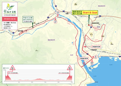
<Goukyaku Mononoke Course>
Restricted only to 100 participants with advanced experience in hill climbing |
→ Enlarged View of Goukyaku Mononoke Course (PDF)
|
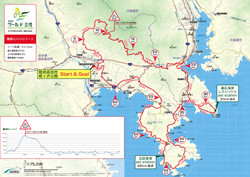
【Goukyaku Mononoke Course】
(Distance 64.5 km, Elevation Gain 1248 m, Average Gradient 5%), Time required: Approximately 5 to 6 hours
Rikuzentakata Community Hall: Tochigasawa Park →Tsudoi no Oka Shopping Street → Hikami Rindo (Forest Road) → Kayooka Toge → Ofunato Hosoura Fishing Port → Goishi Coast (Aid Station) → Hirota Peninsula City Road →Hiroga Fishing Port (Aid Station) → Hirota Peninsula City Road → Apple Road → Takatamachi/Naruishi → Tochigasawa Park
At the beginning of the course are hills where participants ride through the peaceful local village on a hill. Next, participants cycle the forest road with steep slopes whose maximum inclination is 19 degrees for the first 2 km and the average inclination is 11 degrees. The Hikami Rindo (forest road) is also an animal trail where you may encounter deer and serow.
The observation platform at the very top of the hill is a scenic spot that overlooks Rikuzentakata City. After the long downward slope, participants enter Ofunato City and pass through Hosoura Fishing Port to reach the picturesque Goishi Coast. Next, the riders go round the hills of Hirota Peninsula near Rikuzentakata City. As the riders head toward the finish, they can enjoy the scenery of the Hirota Bay with its floating farming rafts. The newly established course is intended for cyclists with advanced hill-climbing experience and is, thus, restricted to 100 riders who meet the participation requirements.
|
|
| |
 |
| |
<Kenkyaku Mountain Course> |
→ Enlarged View of Kenkyaku Mountain Course (PDF)
|
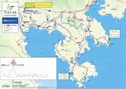
【Kenkyaku Mountain Course】
(Distance: 51.8 km, Elevation Gain 885 m Average Gradient 4.6%), Time Required: Approximately 4 to 5 hours.
Rikuzentakata Community Hall: Tochigasawa Park → Takatamachi/Naruishi → Ubaishi-jinja Shrine → Shimin no Mori/Kesen Daiku Sakan Denshokan → Ofunato City/Matsusaki Junior High School → Goishi Coast (Aid Station) → Hirota Peninsula City Road → Hiroga Fishing Port (Aid Station) → Hirota Peninsula City Road → Apple Road → Takatamachi/Naruishi → Tochigasawa Park
From the starting point, participants ride down the slope and pass through the apple field and ride along a steep forest path of Mt. Hakone. Then, they reach the scenic point that overlooks the Hirota Bay located at the very top of an upward slope to get to the picturesque Goishi coast. Then, they cycle the hills of the Hirota Peninsula near Rikuzentakata City. The cyclists then head for the finish while enjoying views of Hirota Bay before them. This course is intended for those who like hill climbing.
|
|
| |
|
| |
<Kenkyaku A/B Courses> |
→ Enlarged View of Kenkyaku A/B Courses (PDF)
|
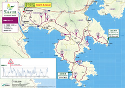
【Kenkyaku A/B Courses】
(Distance: 49.8 km, Elevation Gain 760 m Average Gradient 4.2%), Time Required: Approximately 4 to 5 hours.
Rikuzentakata Community Hall: Tochigasawa Park → Takatamachi/Naruishi → Apple Road → Ofunato City/Matsusaki Junior High School → Goishi Coast (Aid Station) → Hirota Peninsula City Road → Hiroga Fishing Port (Aid Station) → Hirota Peninsula City Road → Apple Road → Takatamachi/Naruishi → Tochigasawa Park
Immediately after participants start riding, the extensive course rises gradually in front of them. They then ride on the apple road through apple fields from Yonezaki area to Ofunato City. They pass through the picturesque countryside of the Goishi coast and cycle the hills of the Hirota Peninsula in Rikuzentakata City. Participants will enjoy superb views of Hirota Bay with its countless farming rafts. The same route is used for the Kenkyaku A and B courses; however, the Kenkyaku B course is especially for those who wish to enjoy the scenery from their bicycles. These are the basic courses for this event; however, as the course name (Kenkyaku course) suggests, there are many hills, so participants are advised to be in good physical condition.
|
|
| |
|
| |
<Family Course> |
→ Enlarged View of Family Course (PDF)
|
【Family Course】
(Distance: 25.2 km, Elevation Gain 103 m Average Gradient 3.1%), Time Required: Approximately 2 to 3 hours.
Rikuzentakata Community Hall: Tochigasawa Park → Takatamachi/Naruishi → National Route 340 (ride on the pavement) → Ipponmatsu Chaya (Tea House) → National Route 45 (ride on the pavement) → Kitano-jinja Shrine Imaizumi-tenmangu Shrine → Yahagicho City Road → Rikuzen Yahagi Station (Turnaround near the station) → Yamabigo no Ie/Shimo-Yahagi Multipurpose Training Center (Aid Station) → Hirota Peninsula City Road → Yahagicho City Road → National Route 45 (ride on the pavement) Hirota Peninsula City Road → Ipponmatsu Chaya (Tea House) → National Route 340 (ride on the pavement) → Takatamachi/Naruishi → Tochigasawa Park
This course gently rises in elevation from the starting point as it heads in the direction of the miracle lone pine tree. Riders will then cross the Kesen River where scars remain of the tsunami as they complete the course and return to the start after enjoying the peaceful rural landscape. This course is ideal for families. Overall, the course is flat and easy to ride with one hill near the finish.
|
|
| |
|